3D MODELING AND AERIAL DRONE SUPPORT FOR YOUR NEXT PROJECT
FROM FLIGHT TO FABRICATION
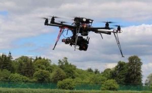
Ace Equipment Sales, Inc. of Willington, Connecticut has embraced drone technology
in a big way. Information gathered from drones is being used in new plant design,
plant remodeling, reclamation projects, stockpile reviews, purchase decisions and
permitting applications for customers in New England and New York. Ace Equipment’s
employees needed to obtain FAA certification to fly drones commercially.
Once the drone flight is completed, the real magic happens. Using a technique known as
photogrammetry, the drone’s photographs are used to create topographic surveys of job sites.
“Rather than relying on expensive aerial LiDAR or time consuming terrestrial
surveys, flying a drone over your site allows us to rapidly and inexpensively
build accurate digital elevation models or point clouds.”
We go one step further, Ace Equipment uses a RTK-GPS Unit.
(Real Time Kinematics) – (Global Positioning Satellite).
This RTK-GPS unit provides a precisely fixed ground reference station to reduce and
remove common positioning errors. Once everything is merged together, the result is a
three dimensional virtual representation of the mine site property where all sorts of information
can be generated and utilized
Ace Crushers Wash Screen Tower Fabrication 3D
Click Play to Interact with our 3D Plant Model Simulation
Use your mouse or pointing device to zoom in and manipulate our design.


